TIMMINS PROPERTY
Project Description
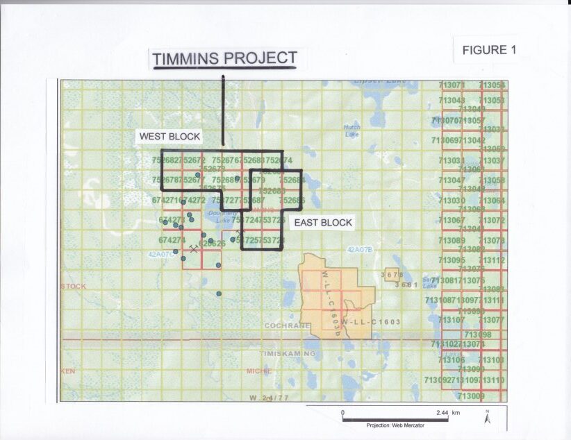
The Timmins property (Dougherty Lake) contains 21 claim blocks comprising approximately 170 hectares (420 acres) and is located in Timmins township approximately 50 km southeast of Timmins Ontario (Figure 1). The property is 100% owned by the Company, is royalty-free, has excellent year-round all-weather road access and is drill-ready.
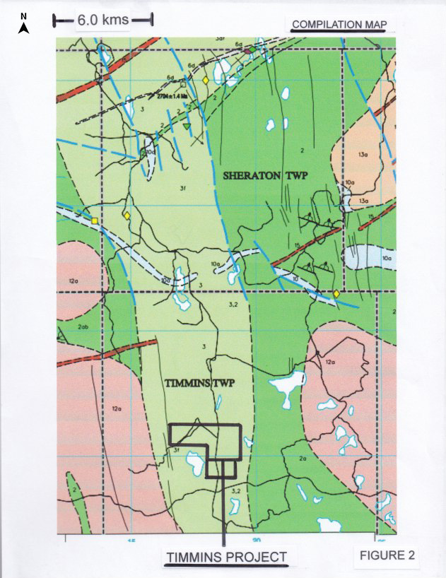
The property is contained within the Watabeag assemblage of northeast trending volcanic sequences sandwiched between the Blackstock and Kasba granodiorite Batholiths. Locally, the volcanic succession under the property is a westward grading sequence of calc-alkalic basalts and andesite to dacite flows, tuffs and metasediments (Figure 2, mndmfiles OFR6042).
The claim block contains two separate favorable geological environments of exploration interest. To the west, the claims are concentrated around three historic boreholes (the Western Block) that encountered extraordinary thick sequences of metasediments carrying anomalous concentrations of base metals similar to the host rocks containing the Cross Lake Minerals Ltd. base metal discovery1 to the north in Sheridan Township (Figure 3). To the east (the Eastern Block), the claims target a strong magnetic high signature intrusive? complex with an associated strong and continuous HLEM anomaly (Figure 4).
THE WESTERN BLOCK
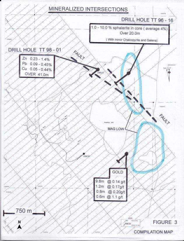
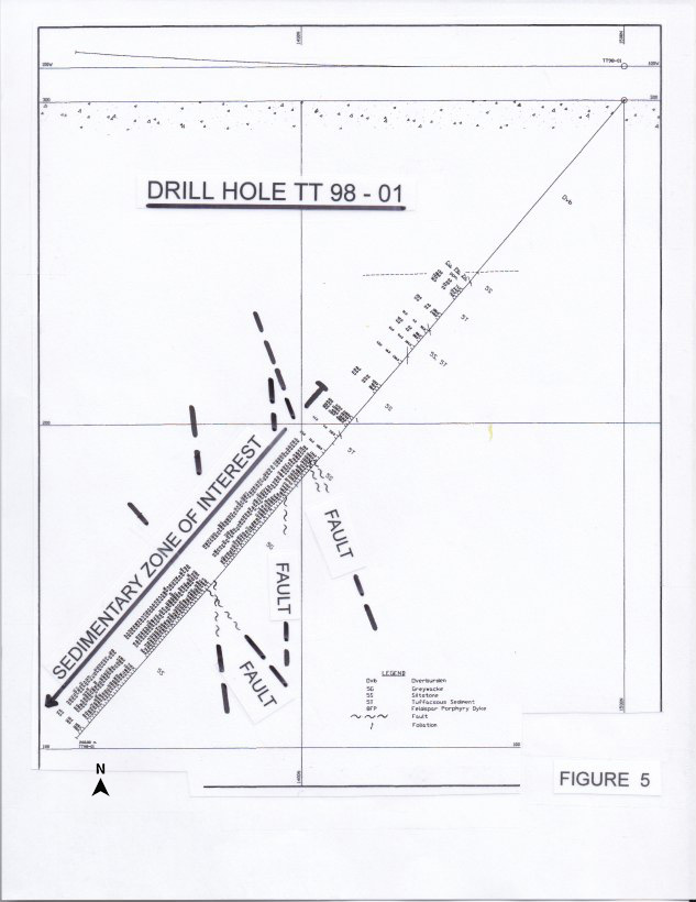
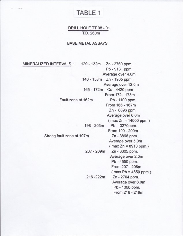
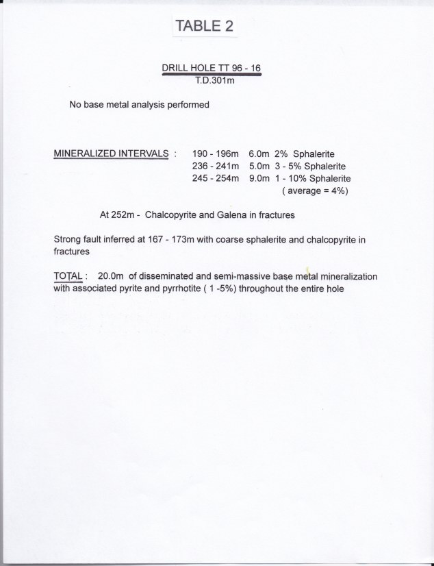
The Western Block specifically targets a thick (20 - 190m) interval of metasedimentary sequences encountered during several previous drilling campaigns (mndmfiles 42A07SE0009, 2004, 0008 and 2003). The metasedimentary assemblages included graphitic mudstone, mudstone-siltstone, argillite and crystal and lapilli tuffs that are locally intercalated with the volcanic sequences. Of specific exploration interest are the multiple sequences black mudstone/argillite encountered in boreholes TT 95-3, TT 96-16 and TT 98 -1. Specific details for each borehole are summarized in Tables 1 - 3. Significant copper, lead and zinc mineralization was encountered over wide intervals in all three boreholes. Sphalerite, chalcopyrite and galena appear predominantly as fracture fillings with carbonate, silica and sericite alteration halos. The base metal mineralization is seen in quartz carbonate veinlets cross cutting the fracture fillings or within cemented fault gouges. Holes TT 98 -1 and TT 96-16 are intensely fractured with several individual fault planes seen in core (Figure 5). The sulfides appear to be epigenetic in character rather than of primary origin. The lack of pervasive alteration suggests that the mineralizing fluids were products of remobilization along numerous fault planes.
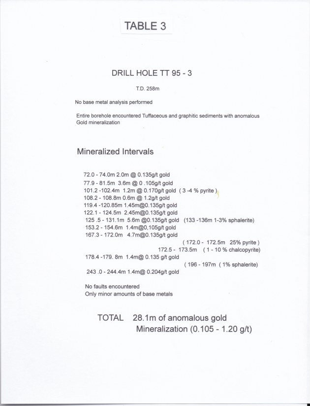
Bore hole TT 95-3 contained 190m of argillaceous, graphitic and tuffaceous metasediments. The hole was not assayed for base metals but did contain several intervals of anomalous gold mineralization found almost exclusively within the black argillaceous/graphitic mudstones (28.1m of 0.105 - 1.20 g/t gold). Intense silicification with associated pyrite (1-15%) mineralization is common throughout the alteration within the gold mineralization.
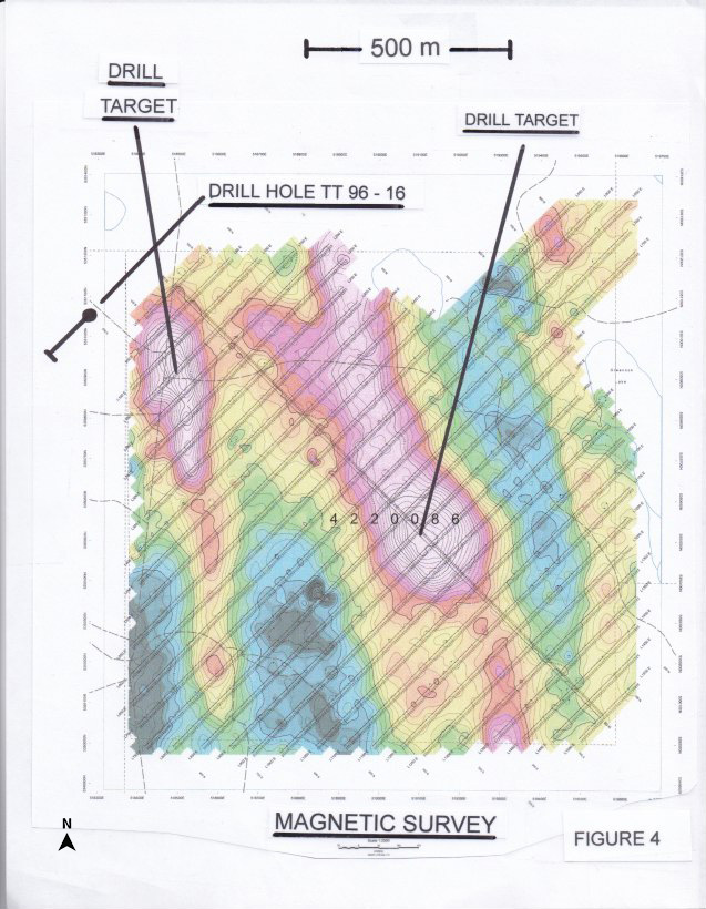
The thick metasedimentary package of tuffaceous and graphitic argillites and mudstones appears to be geophysically associated with a broad area of low magnetic signature. This response may suggest a favorable corridor of extensive hydrothermal alteration near a zone of intense hydrothermal fracturing associated with major fault structure.
Exploration efforts subject to financing will concentrate on geophysics locating the thick sequences of tuffaceous graphitic argillites within the low magnetic signature corridors around the three boreholes as no outcrop exists over the entire claim block. Deeper drilling (to 400+m) may encounter additional fracturing and greater concentrations of mineralization within fault structures that act as conduits for remobilized base metal hydrothermal fluids migrating from deeper intrusive? sources.
THE EASTERN BLOCK
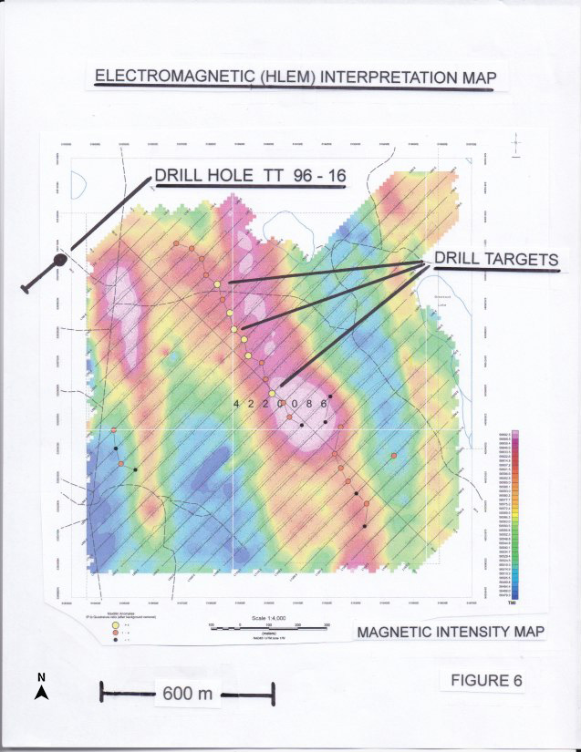
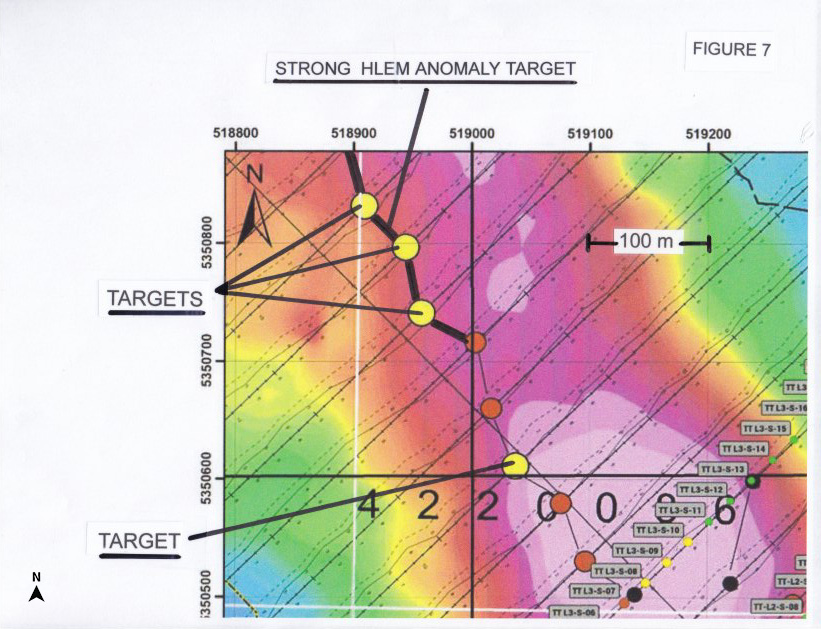
The eastern block specifically targets a locally strong anomalous magnetic high located within a 5 - 7 km north-south trending zone of strong airborne magnetic responses in a complex magnetic system/structure. This specific structure of high magnetic anomalies contains gold and base metal occurrences near Sheridan Lake to the north of the claim block. Locally, the magnetic anomaly of interest is associated with a strong HLEM anomaly which is relatively continuous across the eastern block (Figure 6, mndmfiles 20000019174). It is a good conductor with a depth estimated at between 65-85 m and is considered as an excellent target within this volcanic environment. Once again, no outcrop or boreholes exist on the eastern claim block. A limited geochemical survey was conducted over the HLEM/magnetic anomaly. This survey found weakly to moderate anomalous values of Ni, Co and Cr over and bracketing the anomaly. It is possible that the anomaly could represent a Ni/Co/Cr enriched intrusive? or conductor of ultramafic origin. Exploration efforts subject to financing will concentrate on drilling the HLEM/magnetic anomaly and if successful will continue with several offset locations north and south along strike on the axis of the HLEM anomaly (Figure 7).
1The Timmins property owned by the Company is an exploration target with no resources or reserves and is not known to host like-mineralization as is present at Cross Lake Minerals base metal discovery.
All of the drilling detailed herein on the Timmins property was conducted by previous operators. All drill intercepts are not known to be true widths at this time. The Company has obtained all of the past exploration results for the Timmins property from field work filed and registered at the MNDM, Ontario, as referenced above herein.
(Swipe images on mobile)

QUALIFIED PERSON
The technical information contained in the above text has been reviewed and approved by Mr. Garry Clark, P.Geo., a “Qualified Person” as defined in National Instrument 43-101 – Standards of Disclosure for Mineral Projects.