NORDICA PROPERTY
Project Description
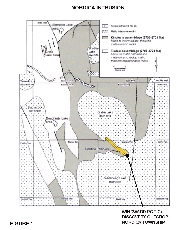
The Nordica Property is contained within the Kinojevis assemblage of northeast trending volcanic sequences sandwiched between the Kasba and Watabeag Lake batholiths. Locally the volcanic succession under the property is a westward grading sequence of mafic-intermediate tholeiitic meta volcanic rocks (Figures 1 and 2, mndm files OFR 6042).
Within the Kinojevis assemblage, the Nordica property contains approximately 75% of the Nordica ultramafic layered Intrusion. The Nordica intrusion is a mafic and ultramafic layered intrusive complex located at the southeast margin of the Kasba Lake granodiorite pluton in northern Nordica Township. Extensive historical exploration programs carried out by Band-Ore Resources and Sedex Exploration revealed several distinct lithologies contained within this intrusion. The Lithologies include Troctolite, Hornblendite and highly magnetic cumulate Olivine Gabbronorite (leucocratic Gabbro) which contain individual massive chromatite units. Magmatic layering is evident in the Troctolite sequences. The mafic-ultramafic suite is intrusive into the Kinojevis assemblage and has been cut by the granodiorites of the Watabeag Batholith.
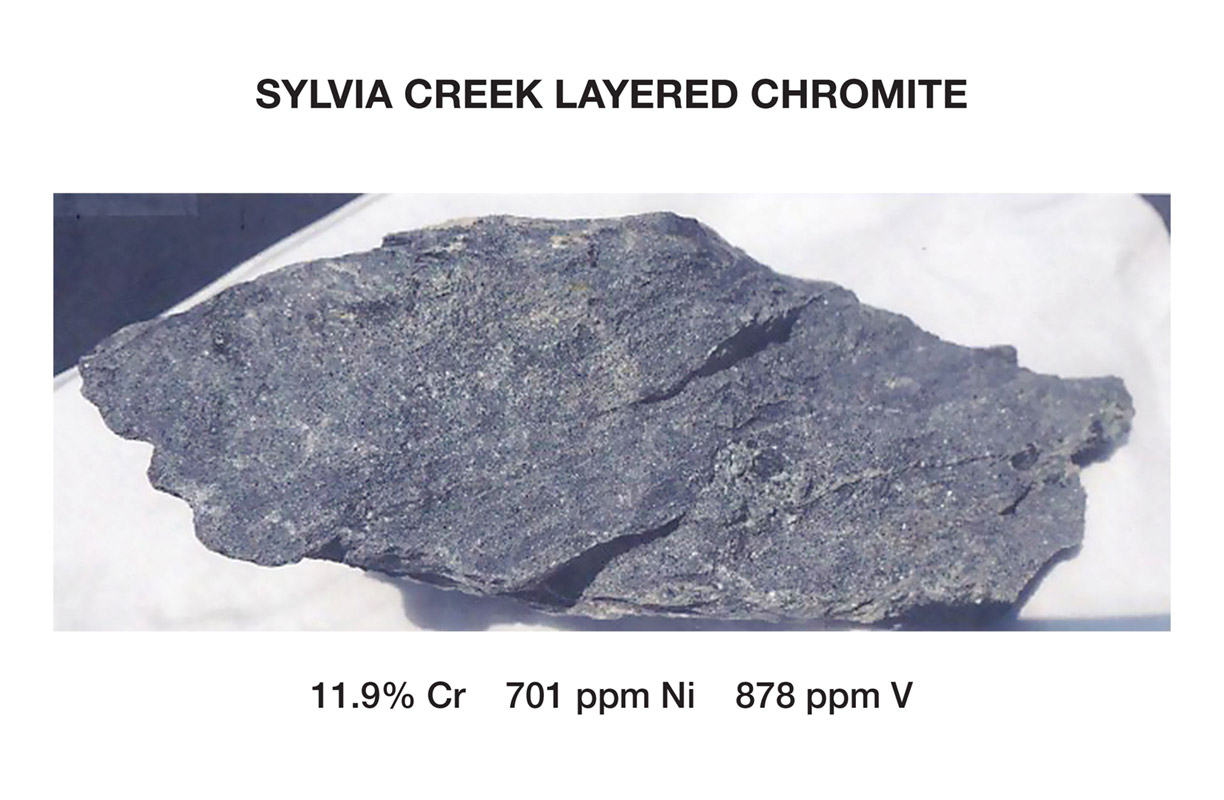
The Hornblendites locally contain up to 8.0% sulphides and the leucocratic gabbro contain 2.0% disseminated sulphides. The Chromatite units vary in thickness from 1.0 - 3.0 meters and individual massive units can contain up to 50.0% chromite.
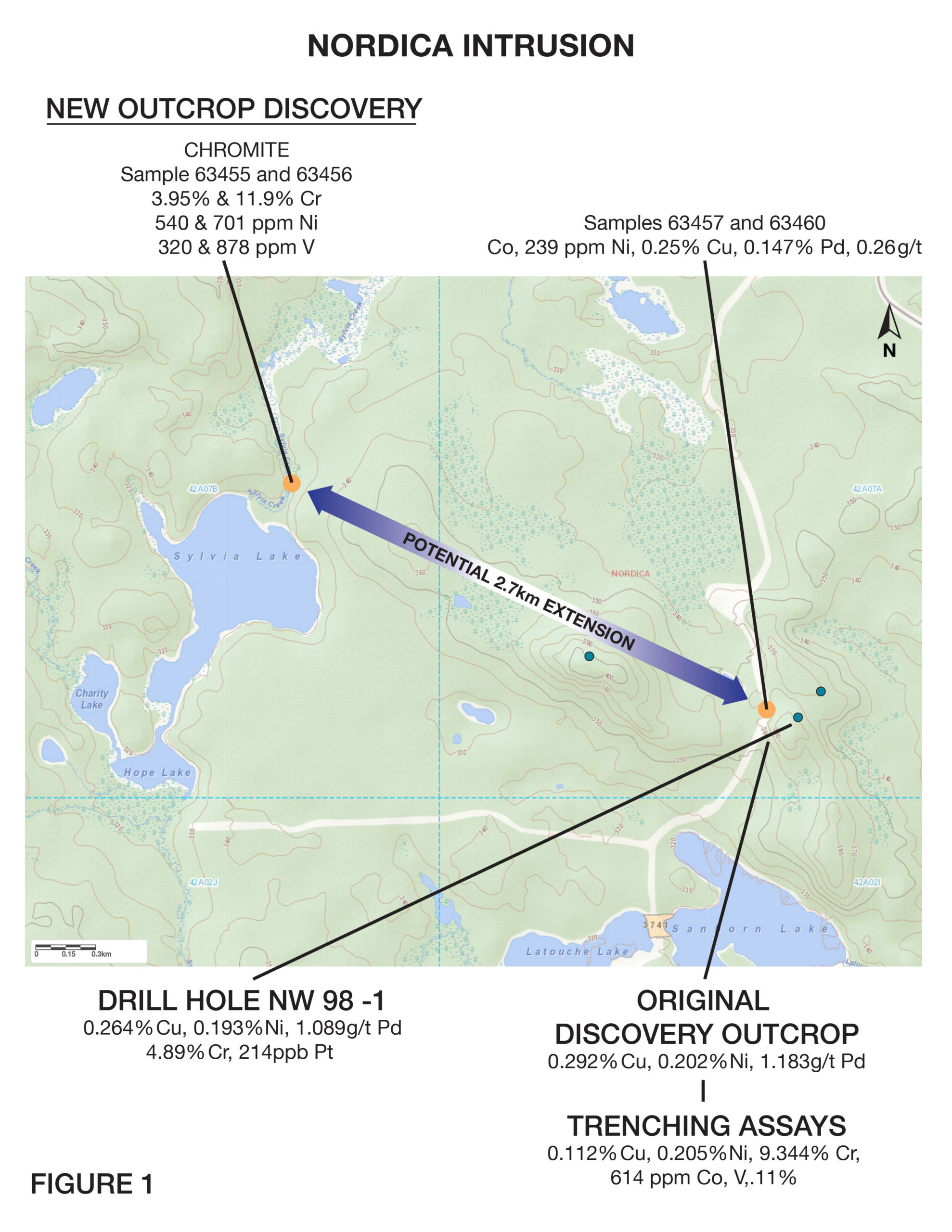
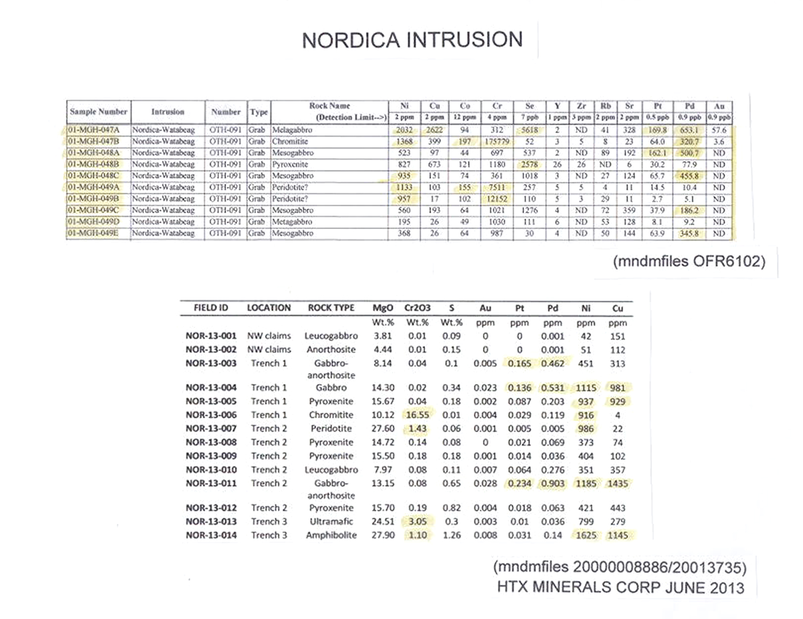
The Nordica Intrusion was originally discovered in 1997. Known as the Windward PGE-Cr Discovery, original grab samples assayed 0.30% Cu, 0.30% Ni and 1.1 ppm Pd. Cobalt (up to 614 ppm) is contained within the chromite layers. Extensive exploration followed the discovery with geological mapping, trenching assaying and diamond drilling (mndm files 20013735). Selected assays from the Nordica intrusion are shown in Table 1 and diamond drilling assay intervals from hole NW-98-1 are summarized on Figure 3 (mndm files 42A07SE2006). Trenching results are shown on Figure 4 (mndm files 20013735). Band-Ore Resources completed two stratigraphic diamond drill holes to cross section a 250.0 m southeast portion of the intrusive
near the location of the original Windward discovery. Hole NW-98-1 cut a 50.0 m wide interval of anomalous Ni, Cu, Pd, Pt, and Cr values across the entire intersection (mndm files 42A07SE2006).
In general, the Nordica Intrusion has assayed up to:
Copper 0.292% (discovery outcrop)
Nickel 0.24% (drill core)
Cobalt 614 ppm (chromite layer)
Chromium 17.6%
Palladium 1.2 g/t (discovery outcrop and drill core)
PGEs 1.0 - 1.3 grams
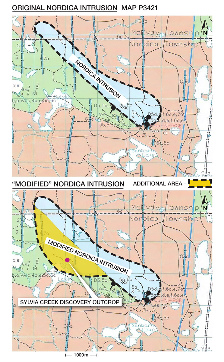
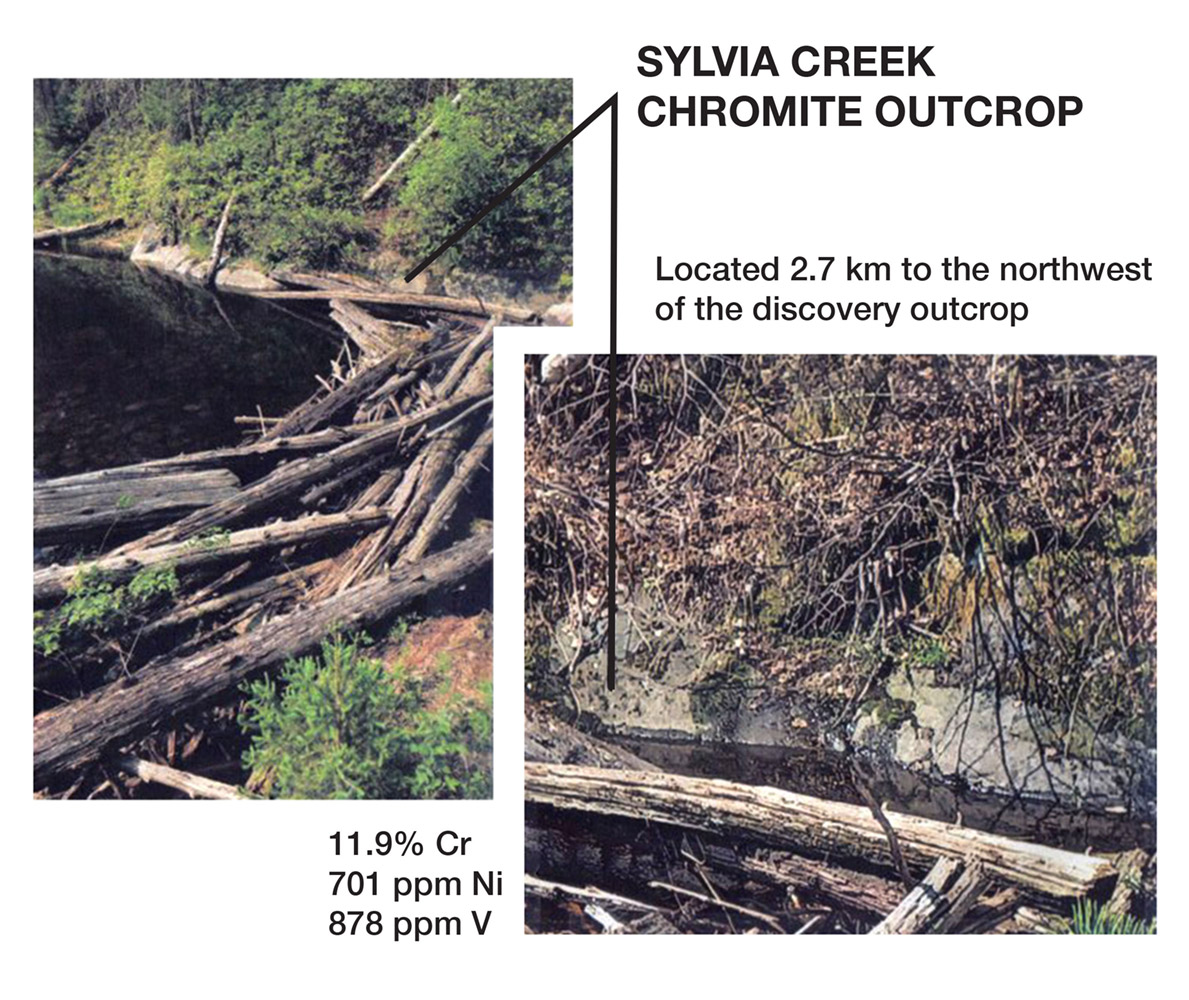
Most of the area is covered by glacial overburden. Government geophysical surveys (mndm files M82219, M82218, M82031, M82047) strongly suggest that the entire intrusive complex could extend in a northwest – southeast direction for 4.0+ kms (Figure 5). It is currently known to be 250+ m wide (southeast edge near discovery outcrop) and scattered isolated outcrops of gabbro extend the intrusive for at least 1.3 kms to the northwest (mndm files 20006208, 20000004200 Figure 6).
Depth is unknown, however diamond drill holes NW-98-1 and NW-98-2 encountered at least 100 meters of ultramafic intrusive assemblage prior to encountering Granodiorite Watabeag (?) intrusive and diabase dykes. Future drilling is warranted on the Nordica Intrusive with the objective to expand the nickel, copper, PGE, Chromium, and cobalt mineralization within the Nordica complex. In addition, future drilling would target new cumulative ultramafic intrusive bodies within the strongest magnetic signatures identified within the prospect.
The company acquired 22 of the Nordica claims directly by map staking and 20 additional claims have been acquired pursuant to a property purchase agreement.

QUALIFIED PERSON
The technical information contained in the above text has been reviewed and approved by Mr. Garry Clark, P.Geo., a “Qualified Person” as defined in National Instrument 43-101 – Standards of Disclosure for Mineral Projects.