MCQUIBBAN PROPERTY
Project Description
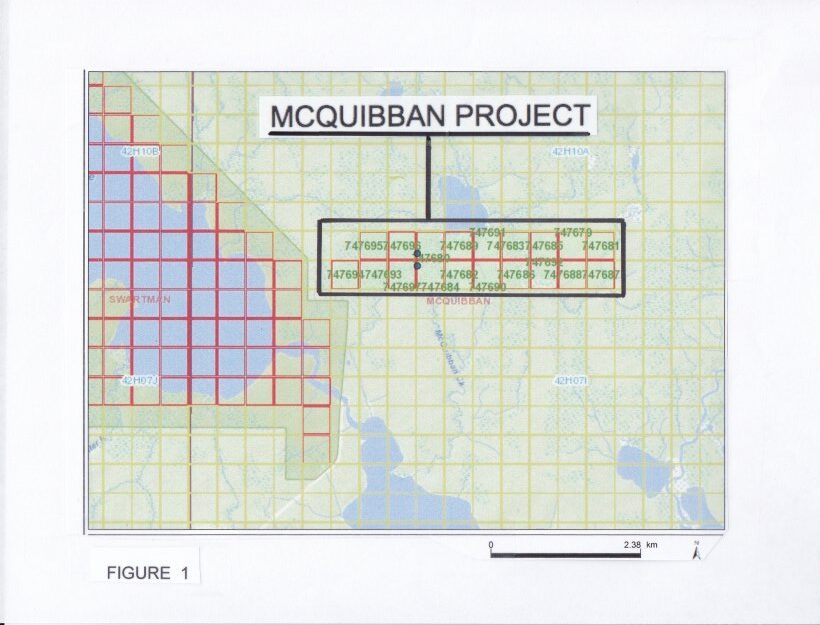
The McQuibban property contains nineteen claim blocks (approximately 153.8 hectares) and is located in McQuibban Township approximately 50 km north of Cochrane, Ontario. The property is 100% owned by the Company, is royalty-free, has excellent year-round all-weather road access and is drill-ready.
The McQuibban property is located within the extreme western extension of the deformation corridor known as the Casa Beradi deformation zone. The 153.8 hectare (380 acre) property (Figure 1) is underlain by east-west trending highly metamorphosed mafic volcanic and metasedimentary sequences containing oxide facies banded iron formation. The property may contain an actual remnant or silver of the Casa Beradi deformation assemblage of volcanic and sedimentary rocks. The entire claim block is covered by extensive glacial overburden.
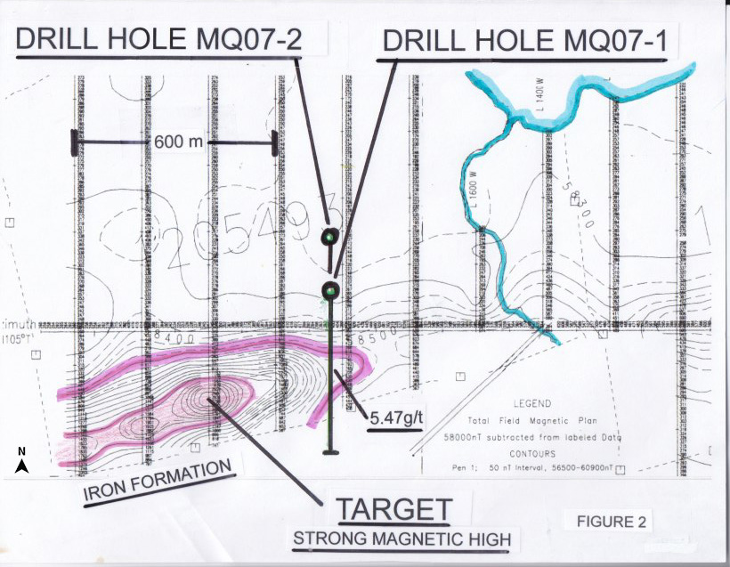
In 1994, Noranda Inc. conducted the first detailed airborne magnetic survey over the property (Figure 2). The survey identified an inferred prominent banded iron formation running in an east-west direction across the entire property. A recommendation was suggested to investigate the banded iron formation which was strongly evidenced on the magnetic survey.
A location was chosen along one of the several faults that transects the iron formation in an attempt to locate gold accumulation within the fractured portions of the brittle iron formation. However, no boreholes were located or drilled on the detailed survey (MNDM Files 42H10SE00001).
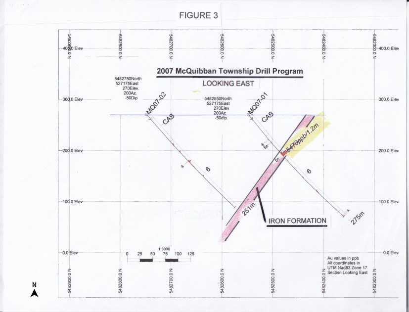
In 2007, Lake Shore Gold Corp. (``Lake Shore``) commenced an exploration program to search for the western extension of the Casa Beradi fault zone and identify structures amenable to gold mineralization. Two drill holes totalling 526 m of core were completed during the program on the property. The boreholes encountered highly strained metamorphosed clastic sedimentary rocks with minor occurrences of chemical metasedimentary banded iron formation and metavolcanic assemblages. Prior to this drilling in March 2007, Lake Shore carried out an extensive high resolution horizontal magnetic XDF-VLF-EM airborne survey over the entire property. Once again, the prominent east-west trending iron formation was identified and extended for a distance of at least 7.0 - 8.0 km along the entire length of the claim block. This survey verified that the iron formation was cut by several north - south trending faults at various locations along strike (Figure 3 and MNDM Files 20000003818/200005750).
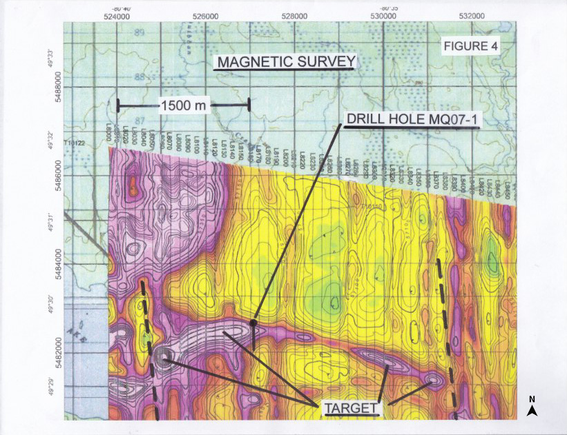
The two drill holes MQ07 - 1 and MQ07 - 2 were drilled on this survey into the iron formation that was seen in detail on the original 1994 magnetic survey. Both boreholes were located along the eastern edge of the high (strong) magnetic signature seen on both surveys. Drill hole MQ07 - 1 penetrated the iron formation whereas borehole MQ07 - 2 (an undercut to MQ07 - 1) was apparently not drilled deep enough and failed to penetrate the iron formation at depth. In borehole MQ07 - 1, a five metre interval of oxide facies banded iron formation was penetrated. The unit is described as a chert - magnetite banded iron formation carrying 1.0 - 5.0% disseminated and banded pyrite and pyrrhotite with fine to medium grained 30.0 - 40.0% magnetite bands. The entire unit runs 6.0 - 21.0% total iron and carries anomalous gold concentrations. One specific assay from the central portion of the iron formation contained 5.47 g/t gold over a 1.2m interval (Figure 4).
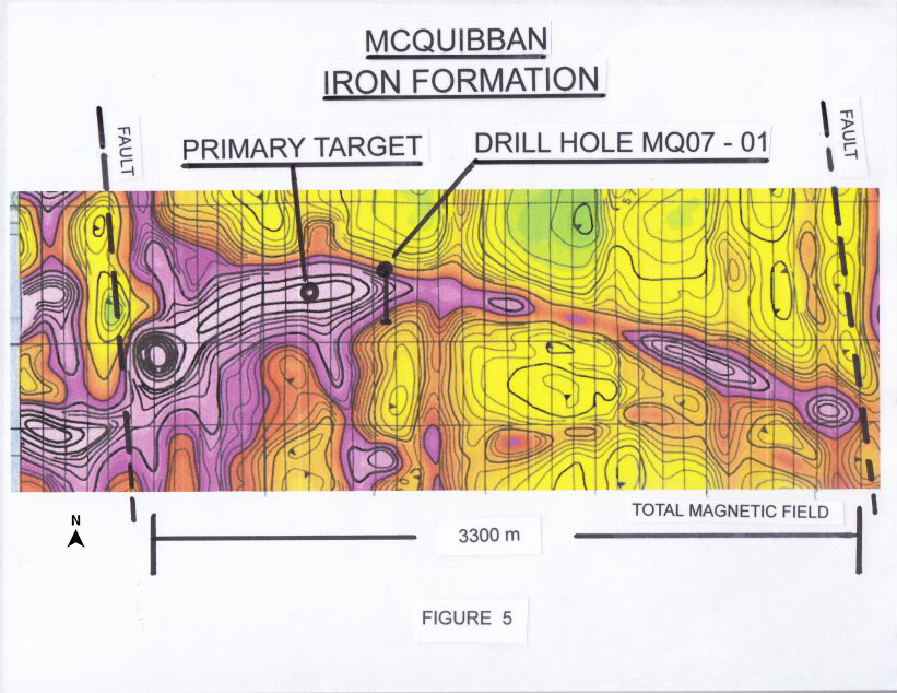
The high (strong) magnetic signature of the iron formation is continuous over the entire claim block. Several stronger (thicker?) magnetic anomalies remain undrilled along the 3.0 km strike length of the iron formation. A very strong magnetic signature is located approximately 200 m to the west of the MQ07 borehole. The magnetic data suggests that a thicker accumulation of iron formation (10.0 - 15.0 m?) represents an excellent target for further gold mineralization. This is the primary drill target. In addition, a large fault with associated high (strong) magnetic signature within the iron formation is located approximately 2.0 km to the east along strike and represents an excellent exploration target for gold accumulation within a highly fractured fault plane in the brittle iron formation (Figure 5).
(Swipe images on mobile)
QUALIFIED PERSON
The technical information contained in the above text has been reviewed and approved by Mr. Garry Clark, P.Geo., a “Qualified Person” as defined in National Instrument 43-101 – Standards of Disclosure for Mineral Projects.