BLAKELOCK PROPERTY
Project Description
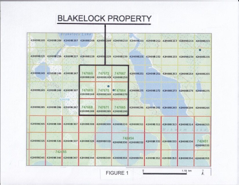
The Blakelock property contains nine claim blocks (approximately 72.8 hectares) and is located in Blakelock Township approximately 75 km northeast of Cochrane, Ontario. The property targets a massive east-west trending magnetic high intrusive complex that was drilled in 1967. The property is 100% owned by the Company, royalty-free, has excellent year-round all-weather road access and is drill-ready.
The Blakelock property is located along the western extension of the deformation corridor known as the Casa Berardi deformation zone, which hosts the Casa Berardi Mine in Quebec some 60 km along strike to the east. The 72.8 hectare (180 acre) property (Figure 1) is underlain by east-west trending arcuate belts of mafic to felsic volcanic rocks which are intruded by several late granitic rocks. Locally a mixed sequence of sedimentary rocks containing sulphide facies iron formation and intermediate volcanics are cut by several felsic intrusives (Figure 2).
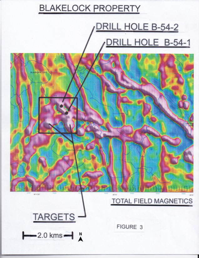
To the southeast of the claim block, in 2010 Lake Shore Gold began an extensive drilling program to test the western extension of the mineralization intersected by previous drilling. The program was designed to follow up on the Esso resources historic borehole HN 88 - 22 which intersected 15.43 g/t Au over 6.9m. All the Lake Shore Gold drill holes targeted an area of strong magnetics suggestive of an intrusive body with associated hydrothermal alteration systems. The program was partially successful as it did encounter some significant gold intercepts such as 2.4m @ 28.41 g/t Au in hole BL-10-28 (MNDM Files 20000006133). The additional drill holes confirmed that the geophysical targets were granitic and porphyritic intrusives containing anomalous gold values. Two diamond drill holes were drilled on the property. Boreholes B-54-1 and B-54-2 were drilled by Texas Gulf in 1967 and targeted a large strong magnetic and EM geophysical anomaly. Both holes encountered several 2.0 - 8.0m lenses of massive sulphides (pyrite, pyrrhotite and minor chalcopyrite) contained within highly metamorphosed metasediments cut by granitic rocks. Hole B-54-1 was drilled to 92 m and encountered metasediments containing up to 30 m of intercalated massive sulphides. The entire metasediment/massive sulphide package is at least 50 m thick as the hole ended in massive sulphides. Hole B-54-2 was drilled to 186 m. The hole began in a metasedimentary/metavolcanic sequence that contained up to 20 m of intercalated massive sulphides, then penetrated a large melanocratic granitic intrusive for the remainder of the hole. It would appear that the massive sulphide section was truncated by this intrusive. No assays were reported for both holes (MNDM Files M82394).
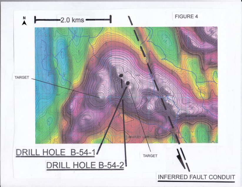
Recent geophysical magnetic programs suggest that a complexed geological structure (intrusive?) exists under the claim block (Figure 3). Stronger magnetic anomalies remain undrilled on the property. Deeper geological control is required to fully understand the potential of the targets and the data suggests that the complex may have been transected by a large north/south fault structure parallel to a large diabase dyke (Figures 3 and 4 and MNDM Files 42H09SE0037).
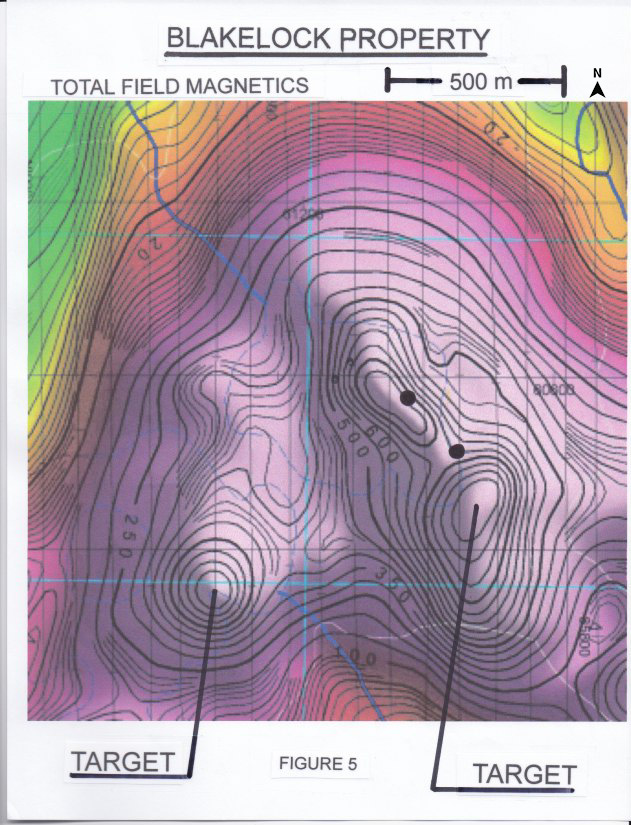
Future drill locations would be designed to intersect the contact zone of a large augen-shaped? intrusive body interpreted as a felsic intrusive stock surrounded by magnetic highs (Figure 5). The potential fault boundary would need to be investigated as the conduit for hydrothermal solutions in association with the felsic intrusive for additional massive sulphide deposition at depth and along strike. Finally, complete assay analyses would be required on all additional drilling going forward.
(Swipe images on mobile)

QUALIFIED PERSON
The technical information contained in the above text has been reviewed and approved by Mr. Garry Clark, P.Geo., a “Qualified Person” as defined in National Instrument 43-101 – Standards of Disclosure for Mineral Projects.